PROJECT STATUS: Under Construction
BUDGET: $2,972,000
Design Concept
The existing Flood-Hope Road corridor (Richmond Hill) used to fall under the jurisdiction of the BC Ministry of Transportation and Infrastructure and was the main highway route through Hope in the 1980’s before the construction of the Coquihalla Highway (BC Hwy 5). Flood-Hope Road is now under the jurisdiction of the District of Hope and functions as a ‘Collector’ road within the community and provides an important connection between the eastern and western areas of the community. Although the corridor width varies from two (2) to four (4) lanes, there are currently no accommodations for active mode users (pedestrians, cyclists, etc) to utilize the corridor.
Construction of a 3.6 meter multi-use path within the existing paved surface is now underway. The design concept involves utilizing existing road structure and width by reducing the existing travelled roadway for vehicles.
Cross Section
As the corridor is no longer needing to accommodate the highway traffic volumes for which it was originally designed, the travelled road width will be narrowed to two (2) lanes and the existing passing and turn lanes will be removed between Owl Street / Beacon Road and the Hwy 1 Exit 170 Off Ramp to allow for the installation of a separated multi-use pathway. Please refer to Figure 1 for the design cross section.
 Figure 1 – Road Cross Section
The multi-use pathway is to be separated from the vehicle traffic by a 0.7m minimum paved shoulder and concrete reinforced barrier (CRB).
The design concept will benefit from traffic calming through the proposed CRB placement and painted pavement
markings. The multi-use path will continue into and cross the intersection at the north end of the project at the Highway 1 Off Ramp and connect to the existing pathway located on the east side of the intersection.
BC MoTI – Highway 1 Off- Ramp
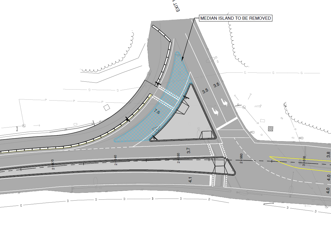
To reduce the Flood-Hope Road corridor from a three (3) lane cross section at the off ramp to a two (2) lane cross section, the BC MoTI Hwy 1 Off Ramp is to be modified by reducing the existing island delineation at the existing intersection. Please refer to Figure 2 which outlines the island area to be removed.
 Figure 2 – BC MoTI Hwy 1 – Off Ramp
As can be seen in Figure 2, the proposed pathway will be constructed in the repurposed existing southern merge lane. A new merge lane will be constructed as a direct taper from the highway off ramp (yield condition) to head west on Flood-Hope Road.
Commercial Vehicle Pull Out Area
Located within the eastern portion of the Flood-Hope Road corridor, a widened area that functions as a commercial vehicle pull-out / rest area exists on the north side of the road. As part of the design, the access points to the pull out will be formalized and delineated in conjunction with the pathway (and pathway crossings). To promote delineation and increased safety for active mode users, additional landscaping is proposed in the existing median area separating the pullout from the pathway and overhead lighting is being installed to increase visibility in the area. Please refer to Figure 3 for an illustration of the proposed pull out area.
 Figure 3 – Proposed Commercial Vehicle Pullout / Rest Area
Beacon Road / Owl Street Intersection
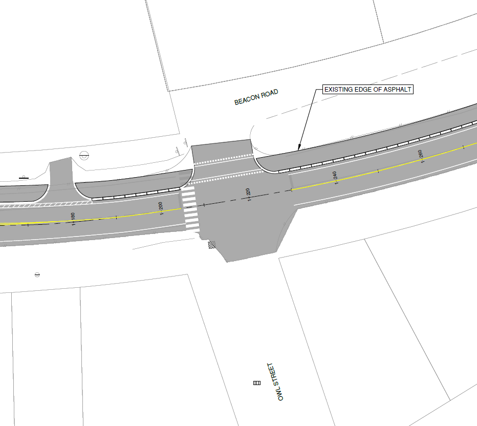
The existing Flood-Hope Road / Beacon Road (Owl Street) consists of one (1) travel lane in each direction, as well as westbound left turn lane (WBLT) which carries on into a two way left turn lane (TWLTL) heading westbound past the intersection to the School Road intersection. As part of the design, the existing intersection width will be reduced to two (2) lanes removing the WBLT and TWLTL in proximity to the intersection. Please see Figure 4 for an illustration of the proposed intersection reconfiguration.

Figure 4 – Proposed Two Lane Flood Hope Road / Beacon Road (Owl Street) Intersection
New Crosswalk to Replace the Pedestrian Overpass
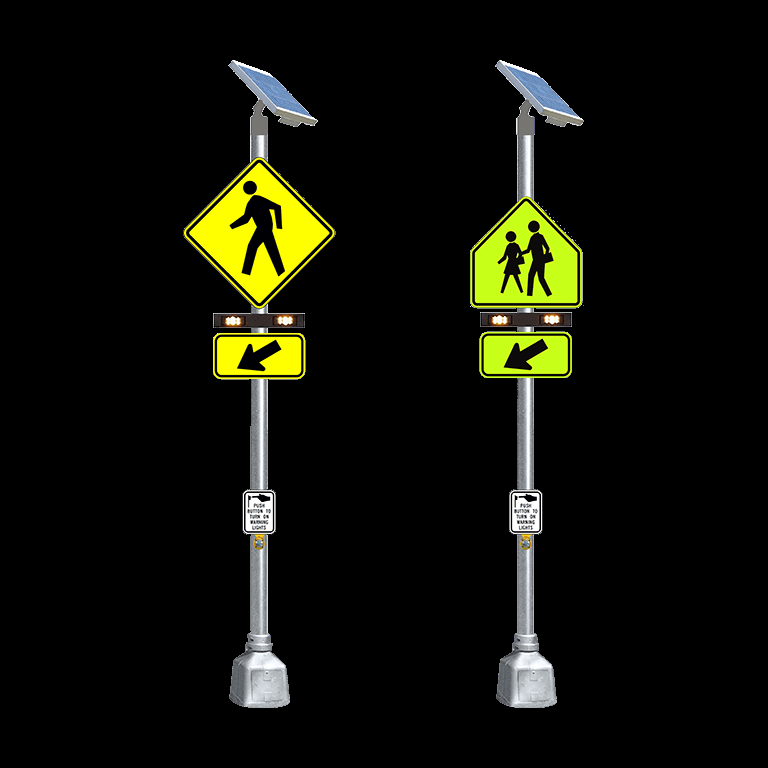
The District of Hope has various options within the Flood Hope Road corridor to install an at-grade delineated surface crossing to replace the previous grade separated crossing. Both Marie Street and Peter Street provide crossing locations that are on the pedestrian desire lines, provide suitable landing areas and allow for the installation additional safety features such as raised median refuge and Rectangular Rapid Flashing Beacons (RRFB's). Please refer to Figure 5 for an example of an RRFB.

Replacing the grade separated crossing with an at-grade surface crossing introduces additional risks and complexities to the road corridor such as increased pedestrian exposure to traffic, increased driver workload, decreased visibility and larger crossing distances. Maximizing the safety elements of the future at-grade pedestrian crossing is important to ensure the well-being and protection of all road users.
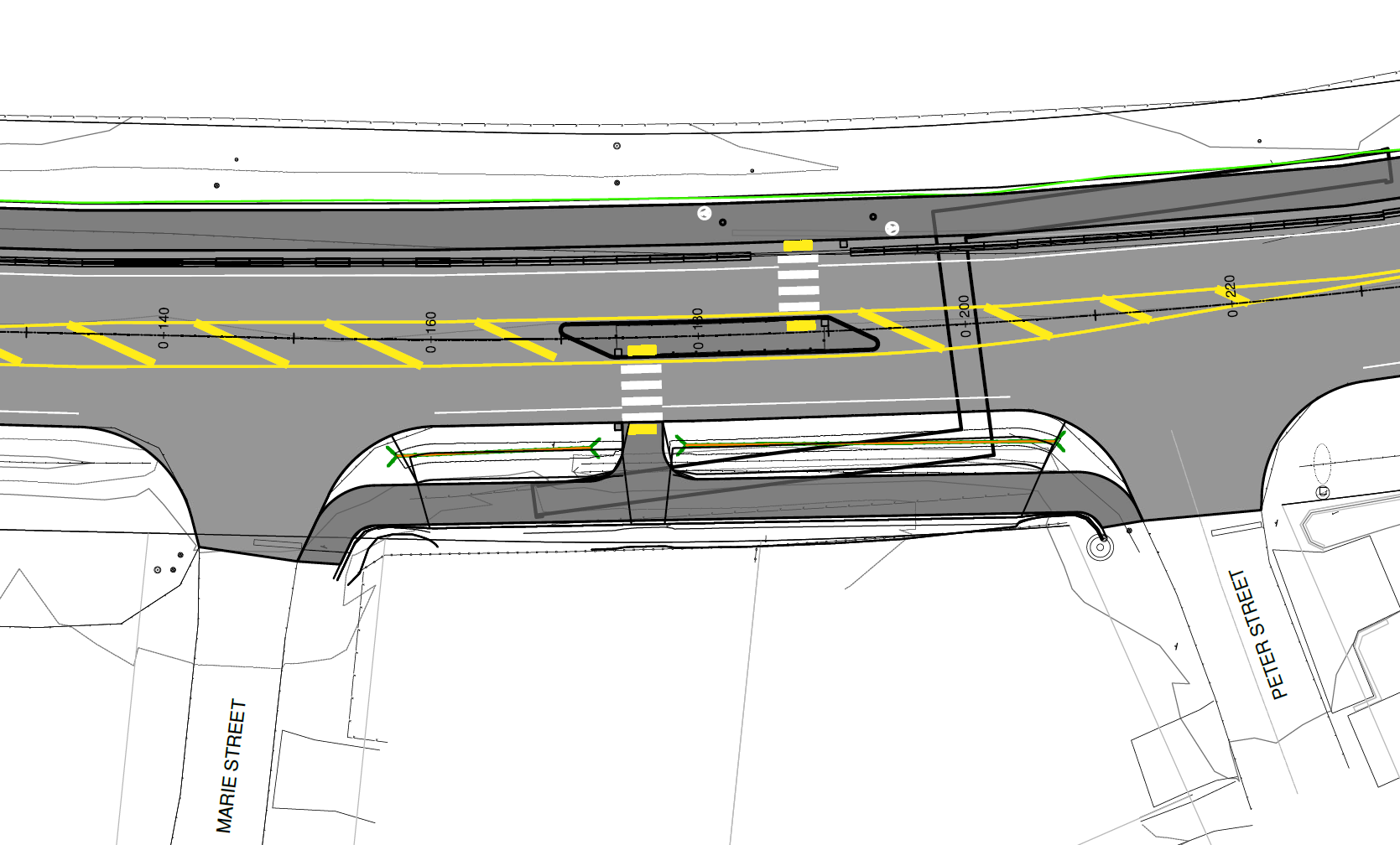
With the introduction of the Richmond Hill Multi-Use Pathway, and the reclassification of the Flood Hope Road corridor to an arterial in the future, the crossing may see an increase in users, increasing the need for more robust safety measures and connectivity to accommodate the diverse range of pedestrians and cyclists. The future crossing will be integrated into the road corridor with considerations for the MUP inclusion, as well as additional traffic calming and safety features.The crossing option chosen involves installing an offset mid-block crossing in the locations between Marie Street and Peter Street. Please refer to Figure 6 for the proposed conceptual configuration.

Figure 6: Recommended Crossing Option
The Flood Hope Road corridor presents a unique opportunity for the District of Hope. Due to the inclusion of the future Richmond Hill MUP and the removal of the grade separated pedestrian overpass, the District has the flexibility to develop the Flood Hope Road corridor in a way that will provide pedestrians and active transportation users with increased connectivity through the community.